North Richmond Collaborative Shoreline Adaptation Plan
Honor Award /
2026, Analysis and Planning
North Richmond, California

Potential risks of sea-level rise include loss of coastal access, wastewater infrastructure and some of the most intact marsh habitats in San Francisco Bay.
©Mithun

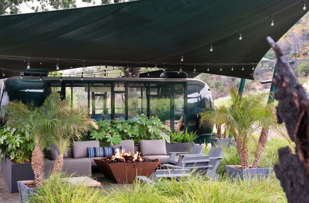
One result of the racist and environmental injustice in North Richmond’s history is a tradition of community leaders organizing for positive change.
Image by ©Mithun/ Photos by ©SamHolman

Returning benefits to community: the position of the existing wastewater recovery facility adjacent to tidal marshes and creeks helps unlock multiple benefits for nature–based adaptation.
©Mithun

Nature-based adaptation: The residential community of North Richmond is low-lying and downwind from a refinery, with infrastructure, transportation and homes vulnerable to flooding and groundwater rise.
©Mithun

Nature-based adaptation: The residential community of North Richmond is low-lying and downwind from a refinery, with infrastructure, transportation and homes vulnerable to flooding and groundwater rise.
©Mithun

Community vision for a resilient shoreline: the ecotone slope levee and public amenities were coordinated to a reconfiguration of the wastewater facility, avoiding the need to fill in existing marshlands.
©Mithun

Phased approach: the co-design techniques led to a Living Levee concept with layers of benefits for access, interpretation and habitat support within the nature-based sea-level rise adaptation.
©Mithun

Collaboration between community vision, and infrastructure needs: the Living Levee’s shallow slope supports the transition of marine life to sea level rise and can host multiple community assets on the land side.
©Mithun

Throughout the design process, community advocates helped frame pathways for economic benefit from the construction and adaptive management of the living infrastructure.
©Mithun

Supporting indigenous programs: field walks with tribal representatives led to incorporation of a small watercraft launch for ceremonial use within the adaptation strategies.
©Mithun

Confirming priorities through shared experience on site: co-mapping field exercises illuminated strong preference for a bridge connection to unite Bay edge access with one of the neighborhood’s beloved amenities: the flea market.
©Mithun

Increasing mobility through SLR adaptation: during working group site walks, community elders shared memories of the shoreline’s pre-development history, identifying a strategy for marsh-creek reconnection.
©Mithun

Generational interconnections: multiple benefit strategies raise, reconfigure and adapt the shoreline with nature-based protection, restoration and regeneration.
©Mithun
Client
West County Wastewater
Project Team
Tim Mollette-Parks, Lead Landscape Architect, Designer, Project Manager
Laura Durgerian, Landscape Designer
Graham Laird Prentice, Landscape Designer
Eddie Divita, Lead Engineer
Naama Raz-Yaseef, Community Engagement Manager
Debra Guenther, Landscape Architect
Project Statement
The North Richmond Collaborative Shoreline Adaptation Plan is exemplary in its use of sea-level rise (SLR) adaptation as a framework for prioritizing community-identified needs, supporting expansion of community environmental leadership while also supporting long-term health of shoreline habitats. The plan invests in nature-based SLR adaptation, intentionally creating direct community benefits to move toward justice in a place that has endured generations of disinvestment and racist environmental and development practices. The co-design process with the community engages residents in long-term adaptation visioning across generations, inspired by their own legacy of environmental advocacy. The plan includes nature-based SLR adaptation five miles of shoreline, and a Phase 1 project called the ‘North Richmond Living Levee’ to catalyze regulatory conversations, agency coordination and long-term governance modeling.
Project Description
The North Richmond community has endured environmental injustice, disinvestment and racist development policies around their housing and infrastructure for five generations. During World War II, black families moved to the San Franisco Bay Area to support the ship-building effort and lived in housing supplied by the U.S. armed services. In the mid-1940s as those families left government housing, they were excluded from accessing housing in surrounding cities. North Richmond emerged as a neighborhood, developed in an ad hoc way predominantly by black families, with little support from public agencies. The area is low-lying, between two creeks and near a Bay tidal marsh. Nearby industrial uses (railroad, oil refineries) have compromised ecosystem and human health. One result of these unjust circumstances is a tradition of strong community leaders and collaborative groups working for positive change on toxicity issues, habitat health, flooding resilience, and housing rights.
This project engages with and supports this ongoing community self-determination. In 2016 a coalition emerged to advocate for sea-level rise (SLR) adaptation that included residents, the local wastewater district, private landowners, volunteer designers, and advocacy groups. They obtained grants from a regional fund for community co-design of nature-based shoreline adaptation — the North Richmond Collaborative Shoreline Adaptation Plan (CSAP). The CSAP pursues human and ecosystem benefits simultaneously. The process connects community members with agency leaders; conducts knowledge exchange between tribal leaders from Confederated Villages of Lisjan, local residents and designers; centers future local workforce development; protects critical wastewater infrastructure and balances habitat migration space with public access.
The plan is rooted physically in two parts. First, a multiple-benefit adaptation at Wildcat Marsh call the ‘North Richmond Living Levee.‘ This catalyst project consists of an ecotone slope and flood protection levee that protects the wastewater treatment facility and accommodates migration of the marsh as seas rise. This part of the scope and its design development drawings have been used for agency conversations about regulatory gaps that make this type of multi-benefit project complicated to approve. This Phase 1 “Living Levee” also supports Bay Trail improvements and restores seven acres of tidal marsh. The collaborative, community-based approach has also attracted funders from both regional and federal sources to move towards construction implementation.
This Phase 1 project (which lies on wastewater district property) further acts as a knowledge- sharing opportunity to extend the co-design approach north and south into more complex property ownership zones. In the north and south ‘clusters’, the plan identifies SLR adaptation opportunities, needed public-private collaborations, and funding plans for 5 miles of shoreline resilience. A foundation in the clusters areas is tribal partnership, with a focus on protecting and honoring sites of cultural concern. In the North Cluster, property owner collaboration resulted in designs for hydrologic reconnection of San Pablo Creek to Wildcat Marsh, restoring a pre-development habitat pattern. Concepts for tidal reconnection of diked ponds and protecting a neighboring capped landfill from wave action are also envisioned. In the South Cluster, agencies and property owners are engaged on nature-based protection of a regional highway and the low-lying residential areas. The CSAP process is often used as a case study for equitable climate adaptation planning, including acknowledgement by the EPA and regional agencies.