Foothill Trail Master Plan
Merit Award /
2026, Analysis and Planning
Alameda County, California

Foothill Trail Master Plan was created by the Hayward Area Recreation and Park District (HARD) in tandem with a districtwide Trails + Open Space Master Plan connecting the Bay, hills, natural corridors, downtowns and neighborhoods.
© WRT

Geographic analysis done for the Trails + Open Space Master Plan generated a layered understanding of people, environment, existing plans and travel patterns, and created a framework of trails for a 104-square mile district.

Foothill Trail Master Plan defines a vision, alignment, and characteristics for a trail skirting the East Bay hills. The Master Plan concept links off- and on-street trail segments and in places separates pedestrian and bike routes.
© WRT

The Master Plan recognizes variations based on land use interface: as part of development on former freeway parcels (above right), in parks (above left) and provides typical cross-sections for off- and on-street trail types.
© WRT

The Plan provides general design guidance for furnishings, lighting, and fencing; wayfinding & interpretation signage (shown here); and public art.
© WRT

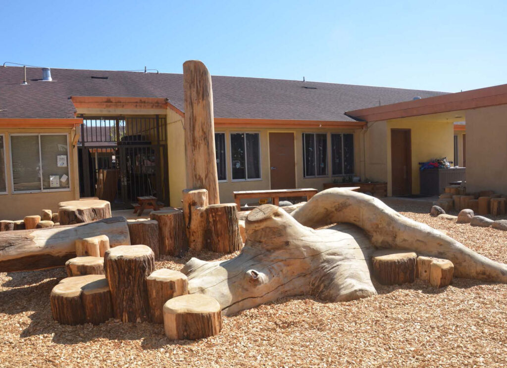
Foothill Trail is envisioned to include periodic amenity zones where seating, interpretive elements and planting may be concentrated. An amenity zone is illustrated here along San Lorenzo Creek.
© WRT

Foothill Trail Master Plan defines individual trail segments as discrete implementation projects that will be carried out by public agencies and through private development on Route 238 Bypass and private parcels.
© WRT

Schematic design was done for Foothill Trail on Parcel Group 8 and in Carlos Bee Park in support of a successful Habitat Conservation Fund grant. The alignment was informed by on- the-ground site analysis using a handheld GPS device.
© John Gibbs

Design work is now underway for the trail segment between Grove Way and A Street, including community exploration of ideas for trail alignments, overlooks, picnic areas and viewpoints.
© Peter Trio

Foothill Trail and San Lorenzo Creekway intersect and share a key access point at A Street. Design ideas for a pocket park here explore a relationship with the sensitive creek corridor, managed by the Sogorea Te Land Trust.
© WRT

Oak woodland, annual grassland, creek and seasonal riparian vegetation create the framework for design at the D and Clay site along the Foothill Trail. Acquisition, habitat restoration and trail design have been funded by State grants.
© WRT

Community members participated in an on-site workshop to consider alternative design ideas for the D and Clay Site along the Foothill Trail.
© Peter Trio

The design concept for D and Clay uses existing vegetation and landforms, generating “moments” where the landscape is experienced: a meadow anchored by natural play, an entry slope garden, and here, the convergence of creeks.
© WRT
Client
Hayward Area Recreation and Park District (HARD)
Project Team
WRT, Lead Landscape Architect
Peter Trio, Landscape Architect and Project Manager
John Gibbs, Landscape Architect, PIC
Jacob Tobias, Landscape Architect
Smera Rose Jacob, Landscape Designer
Michael C. Williams, Landscape Architect and Project Manager
Project Statement
Foothill Trail Master Plan defines a vision, alignment, and characteristics for a trail skirting the East Bay hills in Hayward. The Plan was created in tandem with plans for a districtwide Trails + Open Space Master Plan and for the San Lorenzo Creekway. Foothill Trail, the legacy of a successfully- opposed freeway project, is a unique opportunity to stitch neighborhoods with their natural setting with a lasting recreational asset. The Plan is a critical step in realizing it over time. It gives the trail a detailed alignment, specifies trail types, widths, and amenities, and sets the stage for public projects and segments created with private development. Site analysis carefully examines topography, landform, existing grading, trail connections, vegetation, and opportunities for landscape experience. The Master Plan exemplifies landscape architects‘ engagement with a complex and fragmented environment, and our potential to contribute to a community’s health and connection with place.
Project Description
In the 1970s, a freeway was planned that would have cut through the heart of Hayward. Caltrans assembled over 400 parcels before the project was cancelled due to sustained opposition—a significant victory for the community. A vision for a trail lacked detail until Hayward Area Recreation and Park District (HARD) crafted the Foothill Trail Master Plan (FTMP) in 2021.
Quality of the Analysis and Planning Effort. FTMP is part of a framework that includes a zoning overlay (City of Hayward), a Trails + Open Space Master Plan (HARD), and segment-specific design (HARD, private developers.) The Plan was developed with a stakeholder committee
representing diverse perspectives, augmented by community engagement around design for specific segments. Geographic analysis generated a layered understanding of people and environment at a larger scale; trail alignment was crafted with a close read of land ownership, access, topography, integration with housing development and on-street connections, with further refinement of the Grove Way to Carlos Bee Park alignment done with a site walk and handheld GPS. FTMP addresses key variables: trail typology; access points, points of interest and amenity zones; furnishings, lighting, and fencing; wayfinding & interpretation; and public art. It defines individual trail segments as discrete implementation projects. In short, FTMP provides design guidance at a plan level to ensure comfort, safety and quality of experience with consistency across the corridor.
Quality of Design and Execution. The Plan addresses critical characteristics (e.g. user mix, width, materials, land use context) for each trail type, including both off- and on-street conditions. Access points are indicated, and amenities and site relationships are illustrated. FTMP has been followed by design work on two segments: the D and Clay site near Downtown Hayward and the Grove Way to A Street segment crossing multiple properties and jurisdictions. Here, conceptual design uses existing vegetation and landforms, sculpting open view corridors framed by stands of oaks and eucalyptus, braiding trails to explore small but environmentally diverse sites, and generating “moments:” a meadow anchored by natural play; the convergence of creeks; an entry slope garden; a seating area with a bay view; a trailhead pocket park.
Relationship to Context. Views will create a sense of place in the region, while the trail’s route also provides intimate connections to meadow grasses, forested backslopes, shady creeks, neighborhoods. The trail can tell a powerful story, as a reinvention of a planned freeway. It crosses intermittent streams coming out of the foothills, locations that were culturally significant indigenous settlements and locations of trade and exchange between local Ohlone tribes and continue today with land-back movements with the indigenous woman-led Sogorea Te Land Trust.
Relevance and Impact. Foothill Trail exemplifies landscape architects‘ engagement with a fragmented urban environment and with the complexity of implementation through public and private development. It addresses landscape repair, environmental awareness, and opportunities for active recreation close to home. The trail and associated open spaces provide an opportunity to be physically active, immersed in the natural world, and connecting with others.
Sustainability. Foothill Trail will be a dedicated route for several miles of non-motorized movement, with potential to reduce car dependence. FTMP gives attention to the relationship between trail development and habitat conservation, including careful trail alignment with regard to sensitive vegetation, interpretive/educational opportunities, and stewardship linkages.
Clear Communication of Intent and Project Outcomes. FTMP is a concise, graphic document with a clear structure. This is especially valuable since there is a need to be understood across jurisdictions and be usable for both public agencies and private developers. Subsequent community engagement has been inclusive, with an emphasis on the tangible experience of place for all people.
Likelihood of Successful Implementation. FTMP is a guide to HARD in park and trail planning, and a tool to support Hayward’s development review process in the Foothill Trail Special Design Overlay. Portions of the trail are complete, and others are funded and progressing, including segments at La Vista Park, D and Clay, and between Grove Way and A Street. As part of this latter work, a stewardship framework is being developed to ensure groups such as Friends of San Lorenzo Creek can assist with restoration planting establishment and maintenance.