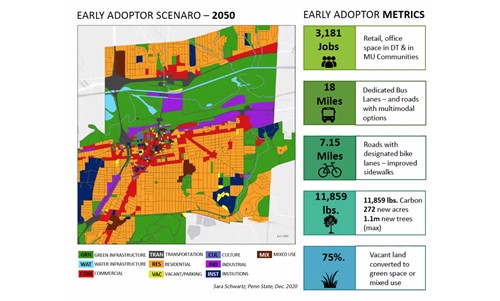
From my earliest days in private practice I was frustrated with how poorly conceived land use regulations “straight jacketed” my design work; I knew there had to be a better way to design communities. This has proven to be a driving force in my career and a key reason I sought to devote my life to teaching and research. My work is rooted in smart-growth design approaches that seek to improve quality of life and respect place, including interactive visualizations of codes and policies so decisionmakers can actually see the potential impacts of their choices. Throughout, I have endeavored to empower people. I am excited to share how I have pursued these goals via a variety of unique, technology-enabled projects, and my more recent focus on Geodesign, which is a dynamic gamechanging strategy to make a positive difference in community design and planning.
Here are some useful links:
Living Atlas (free GIS data curated by Esri)
https://livingatlas.arcgis.com/en/browse/#d=2&type=layers&cont=true
Green Infrastructure data
https://livingatlas.arcgis.com/en/browse/#d=2&q=green%20infrastructure&type=layers&cont=true
Green Infrastructure overview (note the 3 other tabs: Plan, Contribute, Resources)
https://www.esri.com/en-us/industries/green-infrastructure/overview
Geodesign Overview from Esri (scroll to see Case studies)
https://www.esri.com/en-us/arcgis/geodesign
Geodesign YouTube Channel
https://www.youtube.com/channel/UCuRJSZM3xSKWFj8fll0H4OA/videos


